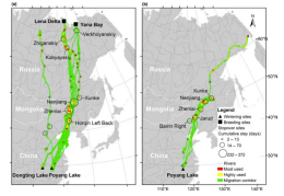
East Asian migratory waterfowl have greatly declined since the 1950s, especially the populations that winter in China. Conservation is severely hampered by the lack of primary information about migration patterns and stopover sites. This study utilizes satellite tracking techniques and advanced spatial analyses to investigate spring mi- gration of the greater white-fronted goose (Anser albifrons) and tundra bean goose (Anser serrirostris) wintering along the Yangtze River Floodplain. Based on 24 tracks obtained from 21 individuals during the spring of 2015 and 2016, we found that the Northeast China Plain is far-out the most intensively used stopover site during migra- tion, with geese staying for over 1 month. This region has also been intensely devel- oped for agriculture, suggesting a causal link to the decline in East Asian waterfowl wintering in China. The protection of waterbodies used as roosting area, especially those surrounded by intensive foraging land, is critical for waterfowl survival. Over 90% of the core area used during spring migration is not protected. We suggest that future ground surveys should target these areas to confirm their relevance for migra- tory waterfowl at the population level, and core roosting area at critical spring- staging sites should be integrated in the network of protected areas along the flyway. Moreover, the potential bird–human conflict in core stopover area needs to be fur- ther studied. Our study illustrates how satellite tracking combined with spatial analy- ses can provide crucial insights necessary to improve the conservation of declining Migratory species.

